Looking for the best hikes in Zermatt, Switzerland?
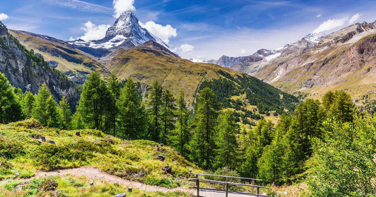
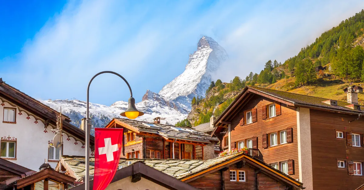
Zermatt is a mountain resort town in southern Switzerland’s Valais canton. Aside from skiing and winter sports, the area is popular among hikers and nature lovers.
Ready To Travel? Don't Go Without Travel Insurance.
I recommend SafetyWing Nomad Insurance, an affordable travel insurance offering automatic monthly payments that you can cancel anytime. I've been using it since 2019, and I can assure you it's the perfect solution for nomads like you and me. Learn more by reading our SafetyWing review.Zermatt sits at an elevation of 5,249 feet (1,600 meters), giving spectacular views of the Swiss Alps.
The most famous mountain here is the pyramid-shaped Matterhorn, with a 14,692 feet (4,478 meter) high summit that attracts experienced climbers and trekkers.
Still, there are many other splendid hiking trails around Zermatt with varying lengths and difficulties.
Therefore, you don’t need to be a hiking pro to enjoy the beautiful alpine scenery in Southern Switzerland. Here are the seven best hikes in Zermatt, suitable for all.
Riffelsee Lake Trail
- Distance: 1.8 miles (2.9 kilometers)
- Duration: 1 hour
Riffelsee Lake is one of the most beautiful places in this part of the country, famed for the mirror-like reflection it gives of the surrounding peaks.
It is stunning at sunrise or sunset and as the hiking trail here is only 1 hour long, heading out early or coming back in the evening is no problem at all.
The Riffelsee Lake Trail is one of the best hikes in Zermatt because it is a leisurely, downhill stroll with a 948 feet (289 meter) descent and just a 1,739 feet (530 meter) ascent.
Moreover, the route passes not only the stunning Riffelsee Lake but also its smaller sister lake.
During the summer months, wildlife sightings, such as black nose sheep and marmots, are relatively common in this area, especially around sunrise and sunset when it is quiet and cool.
The Riffelsee Lake Trailhead is approximately 10 minutes on foot from Rotenboden station and close to the center of town.
Matterhorn Glacier Trail
- Distance: 4 miles (6.4 kilometers)
- Duration: 2 – 3 hours
The Matterhorn Glacier Trail provides a safe path to the glacier and is one of the best longer hikes in Zermatt.
What’s super cool about this route is that it even takes you over one area that used to be covered by the glacier.
At first, the trail may look a bit gray and dull. However, you’ll experience diverse and colorful scenery along the route, from lush greenery to warm orange rocks to white glacier waters.
Plus, depending on the weather and time of the day, the glacier lakes may reflect the mountain peaks. The one-way trail is rated moderate, with more downward walking than climbing.
The course can be rocky at times but is not exposed. At the highest point, you will be 9,606 feet (2,928 meters) above sea level.
You’ll find the Matterhorn Glacier Trailhead below the Trockener Steg cable car station. The route ends in Schwarzsee, where you can get a cable car to Furi and then onto Zermatt.
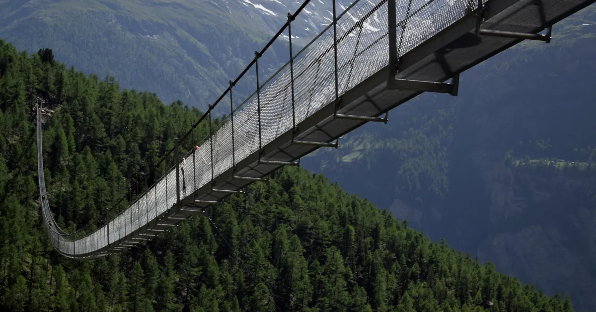
Furi Suspension Bridge Trail
- Distance: 1.8 miles (2.9 kilometers)
- Duration: 1 hour
If you’re looking for the best short hikes in Zermatt, the Furi Suspension Bridge Trail is a must.
The short looped route takes you over a 328 feet (100 meters) long suspension bridge giving breathtaking views of the surroundings and the valley below.
After the bridge, you’ll then walk through a picturesque glacier garden that used to be covered by Gorner Glacier.
Here you will discover tons of strange rock formations, cauldrons, and smooth boulders usually concealed by the glaciers.
The downhill trail has a minimal incline. Plus, at just 1.8 miles (2.9 kilometers), it is a short, easy hike suitable for all levels and fitness abilities.
You’ll find the Furi Suspension Bridge Trailhead at the cable car station in the hamlet of Furi and ends in the 500-year-old mountain village of Zmutt.
Note that the suspension bridge is closed during the winter.
Crystal Trail
- Distance: 3.3 miles (5.4 kilometers)
- Duration: 1.5 – 2 hours
The Crystal Trail is a reasonably short Zermatt hiking trail, yet it is full of beautiful sights. Here you will see the Findel Glacier, Stellisee lake, and the gigantic Matterhorn.
The hike is best to do in the summer as the landscape is full of colorful wildflowers. The one-way route begins in Rothorn and finishes in Blauherd, passing through Fluhalp and Stellisee.
It is located just above the 5 Lakes Trail, but as it’s at a higher altitude, the scenery is entirely different. Therefore, if you have time, you should combine the two hikes, which will take around 4 hours.
You’ll find the Crystal Trail starting point at Rothorn lift station. Follow the signs marked “Kristallweg,” which is the official name for the trail.
The route is gentle, with a total ascent of 387 feet (118 meters) and a descent of 2,093 feet (638 meters).
However, for those with more experience, you can reverse the course, climbing up from Blauherd instead.

Staying In Zermatt?
Make sure to book a stay in one of the best hotels in Zermatt.
Best hostel: Zermatt Youth Hostel
Best mid-range hotel: Studio Omis
Best luxury hotel: Swiss Alpine Hotel Allalin
Five Lakes Trail
- Distance: 6 miles (9.7 kilometers)
- Duration: 3 – 4 hours
The Five Lakes Trail, known locally as 5-Seenweg, is ideal for those looking for a longer and slightly more challenging hike in Zermatt.
The 6-mile (10km) one-way route starts from Blauherd and passes five highly scenic lakes; Stellisee, Grindjisee, Grünsee, Moosjisee, and Leisee, before finishing in Sunnegga.
All 5 lakes are very different in size, shape, and characteristics, so you never feel like you are looking at the same type of scenery.
If you are hiking in the summer and fancy taking a dip, Leisee is the best lake for swimming. Furthermore, Stellisee and Grindjisee give the best mountain reflections.
The Five Lakes Trailhead is at Blauherd mountain station. The trail is marked as moderately challenging and has a 541 feet (165 meters) ascent and 1,490 feet (454 meters) descent.
However, some people choose to hike it in the reverse direction, starting at Sunnegga station.
Doing it the other way around has a gentler start but more overall incline, so it is more of a challenge.
Charles Kuonen Suspension Bridge Trail
- Distance: 5.3 miles (8.5 kilometers)
- Duration: 4 – 5 hours
The 1,640 feet (500 meters) long Charles Kuonen Suspension Bridge is the longest pedestrian suspension bridge in the Alps, giving unmatched views of the Zermatt area.
At almost 328 feet (100 meters) high, you’ll enjoy vistas of the alps, glaciers, valleys, waterfalls, and more as you cross it.
Also known as the Randa Suspension Bridge, you can only reach this attraction on foot via the Charles Kuonen Suspension Bridge hiking trail.
Getting from one side of the bridge to the other takes only 10 minutes, meaning you’ll need to hike for 2 hours first. The rest of the route is not incredible and can be steep sometimes, but it’s still worth it for the views from the bridge.
The Charles Kuonen Suspension Bridge trailhead is in Randa, a short train journey from Zermatt. From the station, follow the signs for “Rundwanderung Hängebrücke Randa,” which is the official name of the route.
Gornergrat Loop
- Distance: 6 miles (9.7 kilometers)
- Duration: 5 – 6 hours
The Gornergrat Loop is rated as one of the best hikes in Zermatt as it gives some of the most astonishing views of Matterhorn along with numerous other massive peaks.
In fact, as the lookout offers 360-degree views, you’ll be able to spot up to 20 mountains, including Monte Rosa, Liskamm, Castor, Pollux, and the Breithorn.
This epic hike also features views of Gorner Glacier, the second-largest glacier system in the Alps, and the reflecting Riffelsee lake.
Plus, at the summit of Gornergrat, you’ll find a railway station, hotel, and restaurants, so you can enjoy a well-deserved drink with a view.
The Gornergrat Loop trailhead is at Riffelalp train station, just a 15-minute train ride from Zermatt. The entire loop is approximately 6 miles (9.7 kilometers) and takes most people between 5 and 6 hours to complete.
However, if you don’t want to complete the entire loop, you can do the one-way option to Gornergrat summit, which halves the distance and time. You can then take the train back down to Riffelalp or Zermatt.
Final Thoughts On Hiking In Zermatt
This list of the seven best hikes in Zermatt is just a small selection of what is available in this part of Switzerland.
With mesmerizing scenery everywhere you look, hiking in Zermatt is never dull.
Plus, with a gondola station always close, you can make your hikes shorter whenever your legs feel too tired.
Unsure if you can fit Zermatt in your Swiss itinerary? Read our blog post to see if Zermatt is worth it.
Visiting Switzerland soon? Read the following guide: